This is the northern section of the Alexandria Branch of the Pennsylvania Railroad. I followed it from Route 981 to Loyalhanna Creek. The area closest to Rt. 981 is a little confusing as to what you are actually following. There is an old road that ran alongside the railroad for a short distance which kind of threw me off as far as the bridges were concerned. I narrowed it down to three bridges that I believe were part of the roadway and two that were part of the railroad. I have no idea if the road even had a name, but from old maps predating the construction of the Loyalhanna Dam, it shows that it went north for a short distance and ended near the creek. What threw me off initially is the fact that I was walking on old blacktop. I think I narrowed it down though.
Also, I am still unsure when this section was built. We know the branch reached New Alexandria in 1901. It doesn't show up on the 1902 map and it doesn't show up on the 1941 map. Somewhere between those years it was built, used, and abandoned. It was built to serve the mines at Andrico which closed in the 1930's. The earliest mine at Andrico opened around 1908.
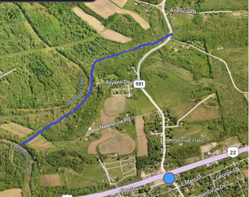
First off, here's the area on a modern satellite image of the area. The railway is roughly highlighted in blue.
And now here is the area from a 1939 aerial photograph with the railway highlighted in blue.

And finally the same 1939 photograph that I detailed to show some of my confusion. I have the area circled in red and the railway is not highlighted.

Sooo.... after all that, here are my photos.
 |
| This is the first of the railroad bridges. |
 |
| And this is the first of the roadway bridges taken from on top of the railroad bridge. |

 |
| This is the spot where the confusion sets in. On the left is the roadway. On the right is the railway. Right here they meet and it's hard to figure out what's what for a while. All I know is there's old blacktop for a little bit. |
 |
| This is the big roadway bridge. |
 |
| Underneath the roadway bridge. |
 |
| This nice pool had a lot of fish swimming in it. This section of the railway and roadway run along Tub Mill Run. It's a tributary to the Loyalhanna. |
 |
| Now to me, this looks like a roadway bridge due to it's concrete deck. But where is the railroad bridge? It had to cross this creek too. |

 |
| This is looking up Tub Mill Run. |
 |
| This is after the blacktop ended and we are certainly on the old railway. |

 |
| This is definitely a railroad bridge. |

 |
| The trail is really nice to follow through here. At about this point you can't hear traffic from 981 and you're not at the point yet where you hear can hear Rt. 22 traffic. A little further down is the mouth of this creek. |
 |
| Right here is entering a cut a on the railroad. The way the cut goes to the right leads me to believe there was a siding here as well. |
 |
| A better view of the cut and possible siding. |
 |
| In the cut. |
 |
| An old sealed up mine. |
 |
| This is a clearing. The railroad grade is visible in the middle of the photo. |
 | |||
| At the clearing looking at the Loyalhanna. |
 | ||
| Heading down the grade from the clearing toward the bridge abutment. Eventually. After this is another cut that is totally overgrown. I had to walk through a field to the Loyalhanna Creek and climb down into the cut to get to the bridge. |
 |
| Looking at the overgrown cut from the bridge abutment. |
 |
| On top of the eastern bridge abutment. |
 |
| The side of the abutment. Nice huge cut stone. If you go here, don't climb down the bank like I did. It's very loose mud and I ended up at the bottom a lot quicker than anticipated. |
 |
| But while I was down there I took this picture of the front of the abutment. |
 |
| I managed to climb up out of there on the other side of the abutment thanks to some nice strong roots. Otherwise I'd probably still be down there. |
 |
| Looking down from the top of the abutment. It's hard to tell but this thing is pretty high. |
 |
| This is looking across the Loyalhanna at the western abutment. I was going to try to reach this side from Route 22 but that's going to wait til another day. |
 |
| A close up of the western abutment wall. |
 |
| Looking down from the eastern abutment before heading back. |
 | |
| Back at Route 981. The railroad continued down this way. This is currently a driveway to a private residence. |
And here's a couple wildlife photos to close out with.


Update 10/7/2014. A view of part of the grade and bridge abutments from Loyalhanna Creek.


