Well the tracks have been pulled up and the corridor is well on its way to becoming the third stage of the Westmoreland Heritage Trail. At lot has changed since the last time I walked the railway. For one, it's a lot easier going. The last time I came through here it was so incredibly overgrown but the tracks were still here. It definitely had the feel of a ghost railroad. That can be seen here in this prior post Turtle Creek Branch 2013
This section of the railway dates back to 1891 and 1892. I wanted to get it post tracks-pre trail. Now, the sections that were so overgrown it was hard to see the tracks are completely bare. The Franklin Township Municipal Sewage Authority is busy building a new pipeline in one section and it is marked "No Trespassing". Seeing how nobody was working today, I didn't think they'd mind if I went through anyway. They didn't. The whole railway is bikeable and I had no problems anywhere on the whole ROW. It's still sad seeing this railway bare of tracks for the first time in 123 years. On the other hand, it is a very scenic trail and it's great that it's not being used for some cookie cutter housing development or strip mall. It is a nice ride.
Starting off in Export, Export has chosen to keep the tracks from the siding and their caboose that is being restored. The town would not be the same without its tracks. It was such an important town.

The huge tipple for the Westmoreland Coal Company's mines at Export.
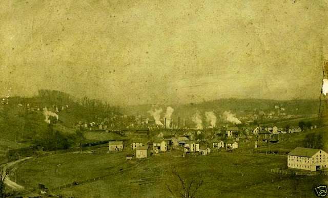
An old photo of Export.
Today's photos.

The huge tipple for the Westmoreland Coal Company's mines at Export.

An old photo of Export.
 |
| The first bridge leaving Export. |
 |
| This one is still pretty sturdy. Some of the bridges a little further down are kind of sketchy. |
 |
| Hardware nice and intact. |
 |
| The backside of the bridge. |
 |
| One of the abutments. |
 |
| Heading west on the old railway. |
 |
| The first road crossing at Van Buren Street. The tracks are still intact in the road. |
 |
| The Route 22 bridge. |
 |
| The next road crossing at Haymaker Farm Road. Murrysville wasted no time in tearing these tracks out. |
 |
| The next bridge. This one is in pretty rough shape. The deck is anyway. The bridge itself is certainly sound. |
 |
| A lot of rotten railroad ties. |

 |
| Looking down. |
 |
| One side of the bridge. |
 |
| Heading west. Still very nice to ride on. |

 |
| A tie plate. I can't figure out the manufacturer of the plate yet. It is marked DP CO-29-HW. I can't figure out what DP Co. is. I understand 29 as being a 1929 manufacturing date. HW I'm also unsure of. Help please. |
 |
| The next bridge. This one wasn't bad to cross. In the distance you can see School Road in Murrysville and the sports complex. |
 |
| One side of the bridge. |
 |
| Some remaining tie plates on the bridge. |
 |
| Approaching School Road. |
 |
| Tracks still intact at School Road. |
 |
| Heading through the Caterpillar dealership. |
 |
| Tracks still intact at the entrance of the Caterpillar dealership. |
 |
| I wonder how long this sign will remain. |
 |
| 7 miles to Trafford. |
 |
| Next crossing at Lilian Avenue. No tracks left. |
 |
| A lonely siding that is no longer connected to a railroad. |

 |
| Next crossing at Carson Avenue. No rails here. |
 |
| The bridge before Trafford Road. This bridge (deck) is in horrible shape. I don't remember it being so rough a couple years ago. No photos of the deck because I couldn't wait to get across it. |
 |
| Trafford Road still has tracks. |
 |
| No more tracks at the Meadowbrook Road crossing. |
 |
| Heading west. This is a really nice section. |
 |
| Turtle Creek. |

 |
| 5 miles to Trafford. |
 |
| This section runs through a really steep hillside. |
 |
| Pipes for the new sewage line. |
 |
| Another shot of the hillside. |
 |
| 4 miles to Trafford. |
 |
| This is my favorite bridge. It is located at the sewage plant. The turnpike bridge is in the distance. |
 |
| Turtle Creek off the sewage plant bridge. |
 |
| Looking off the bridge. |
 |
| Underneath the turnpike. |
 |
| Looking east after the turnpike. On the right is the Lyons Run branch. |

 |
| Looking over at the Lyons Run grade. |
 |
| The crossing at Saunders Station Road still has tracks. |
 |
| The first bridge after Saunders Station. Two years ago there was a torrent of water running under this bridge. Now it's bone dry. |
 |
| It's a small bridge. No problem crossing here. |
 |
| Looking off the next bridge at Turtle Creek. This bridge is completely dirt covered. |

 |
| Heading west. |
 |
| 2 miles to Trafford. |
 |
| The Forbes Road crossing still has tracks. |
 |
| After the Trafford Community Park is this section where the tracks are still intact. |
 |
| A switch. |
 |
| For the remainder of the Turtle Creek Branch there are still tracks. |
 |
| Heading into the Trafford yard. |
 |
| Looking over at Trafford. |
 |
| Some rail maintenance vehicles at Trafford. Maybe this is what they used to take up the tracks. |

 |
| This piece of equipment seems like it picks up rail hardware. |

 |
| Turning around and heading back toward Export. |
 |
| Before heading back I stopped at Michael's Neighborhood Grille at the corner of Forbes Road and Rt. 130 in Trafford. Really good food. Check it out! |
 |
| A small waterfall I missed before. It's probably very nice after a heavy rain. |
 |
| I took a quick run up the Lyons Run Branch on the way back. Turtle Creek was pretty low today and I was able to get this photo of (what I assume is) Lyons Run flowing into the creek. |
 |
| I was told this rock laying underneath the turnpike bridge was part of the old Lyons Run Branch bridge abutment. |
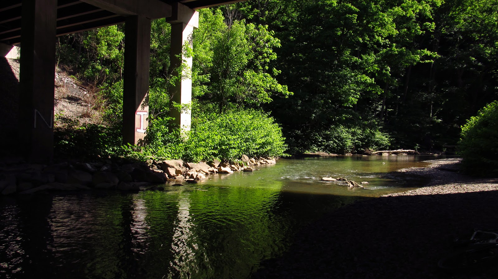 |
| Looking down Turtle Creek under the turnpike bridge that crosses it. |
A nice write up from the Delmont Salem News 9/16/2015 about the old railway.
