The Turtle Creek Branch of the Pennsylvania Railroad was chartered by George Westinghouse in 1886 to supply the Murrysville oil fields with supplies. Beginning in Trafford, the rail line was originally called The Turtle Creek Valley Railroad but was also known as Westinghouse Road. Service began to Murrysville in 1891 and was expanded to Export in 1892. The Pennsylvania Railroad operated the line and eventually purchased it in 1903.
Passenger Service was first offered in 1894 and continued until 1936 when demand for the service had fallen.
These photo's are of the original 1891 line. I started at Forbes Road in Trafford and followed the line to Murrysville. I also located the Lyons Run Branch which served the coal mines in Pleasant Valley.
Currently the line is known as Turtle Creek Industrial Railroad and is owned by the Dura-Bond Corporation in Export although it seems like it's been some time since they've used the railroad.
 |
| This is the first bridge you come across heading east from Trafford. Turtle Creek is running very high. |


 |
| This is the condition of the railroad in most areas. It obviously hasn't seen a train in a few years. |

 |
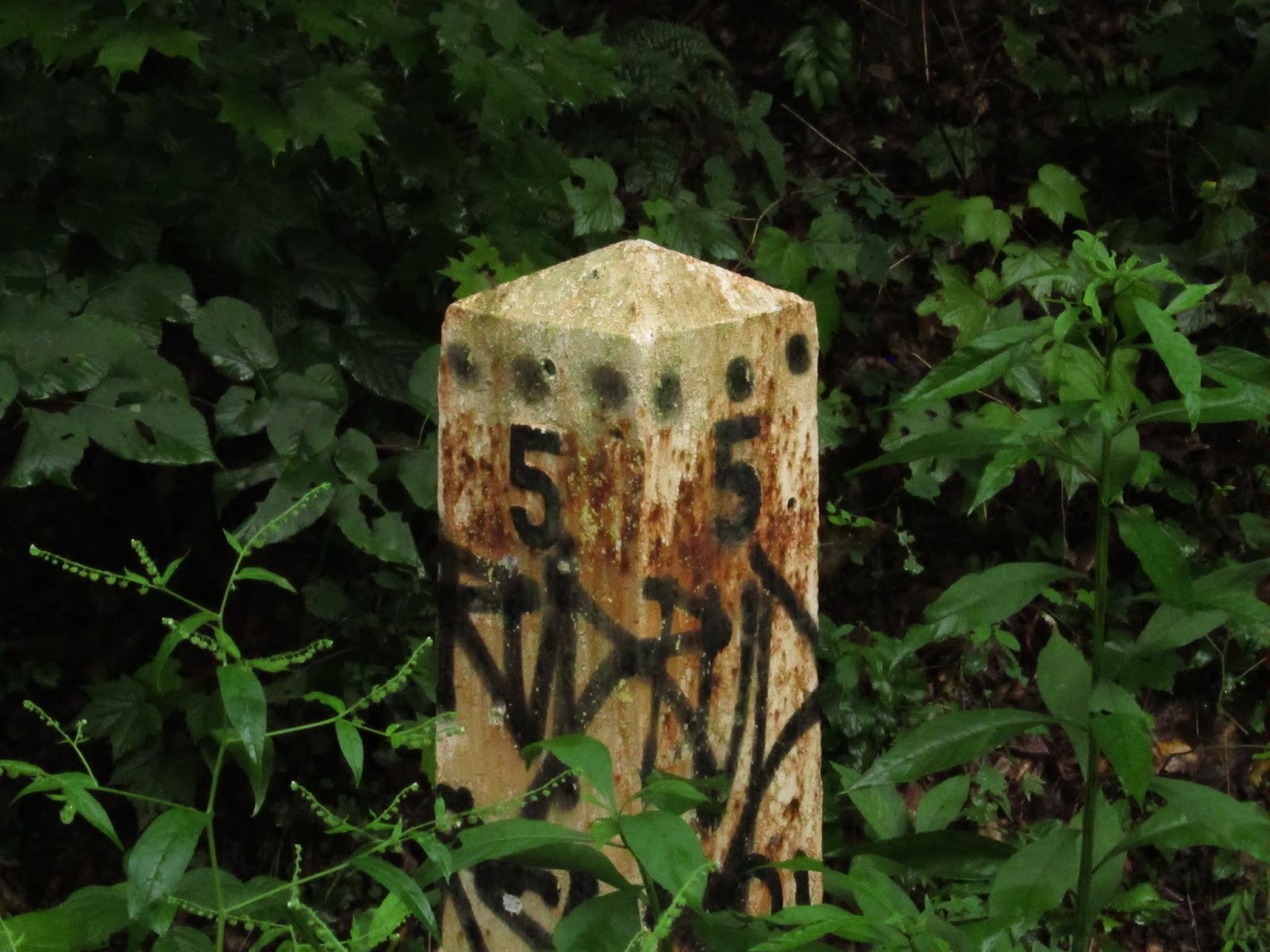
| I'm not sure if the 1926 on this piece of bracing hardware is the manufacture date. If it is, these rails are pretty old. UPDATE 8/18/14- Somebody wrote in telling me this was a 1926 tie plate manufactured by Bethlehem Steel. Pretty cool. |
 |
| Two miles out of Trafford. |

 |
| This is an old Conrail truck trailer sitting beside the last business on the line leaving Trafford. Conrail ran this line later until they abandoned it in the early 80's. |


 |
| Some wildflowers growing along the rails. |
 |
| This is the second bridge. It's smaller than the first and I'm not sure if this is over Turtle Creek or over a tributary. |

 |
| A washed out section of the railroad. There were quite a few areas like this on the way to Murrysville. |
 |
| On the right is the Lyons Run spur. From what I can tell from old maps, at least a portion of the current turnpike was built on this spur. The section of the turnpike near the Franklin Township Sewage Authority down to near Pleasant Valley is where the line ran. The turnpike bridge over Turtle Creek was originally the site of a railroad bridge for this spur. The Pennsylvania Railroad filed for abandonment of the nearly four mile branch on 11/7/1949 and this section of the turnpike was completed in 1951. |
 |
| More Lyons Run Branch. |
 |
| This was laying in the ground at the juncture of the Turtle Creek and Lyons Run branches. Possibly an old switch? |
 |
| Underneath the turnpike bridge over Turtle Creek. This is the location of the old Lyons Run bridge. The creek was very high. I was hoping to see some of the stonework from the old bridge but if there is any, it's underwater at the moment. |
 |
| Allegheny County border sign that should have been on the bridge, not laying on the ground under the bridge. |
 |
| More Lyons Run Branch. |
 |
| This is the Turtle Creek Branch bridge that carries the turnpike over the railway. The sewage plant is on the other side. |
 |
| The third bridge and a big one. This crosses Turtle Creek and comes out at the sewage plant. You can see this bridge from the turnpike. |

 |
| The stretch of railroad past the sewage plant is pretty rough until you get into Murrysville. |
 |
| Five miles out of Trafford. |
 |
| More rough railroad. |
 |
| Coming into Murrysville. The "Whistle" sign before the Trafford Road crossing. |
 |
| The fourth bridge at Trafford Road in Murrysville. |


 |
| The Haymaker Gas Well marker. The reason the rail line was built. |
 |
| Model oil derick built by the boy scouts at the Haymaker Well site. |

This is the section covered in this post. The yellow is the main line of the branch and the red is the Lyons Run branch.

This is a clipping from the August 27, 2014 Delmont Salem News about the final movement of a locomotive on the Turtle Creek Branch of The Pennsylvania Railroad. 122 years of rail history effectively ended on Monday, August 25 2014. Thankfully the railway will be saved as a trail, preventing it from development or destruction.

Another nice write up from 9/16/2015 in the Delmont Salem News.

Great photos, Love the history!
ReplyDeleteThank you Gwendolyn!
ReplyDeleteNice photos! I'm familiar with the area, but I never knew about the Lyons run branch. Interesting, where exactly is the join with TCKR in relation to the turnpike? Is it between saunders station road and the turnpike? I didn't quite recognize where those pics were taken.
ReplyDeleteYes, it is between Saunders Station Road and the turnpike. If you look at the rail line on a map, look at where the railroad forms an "S" at the turnpike. The branch for the Lyons Run is at the bottom of the "S". It's very close to the turnpike. Try this old map and compare it to a current one. It looks like the turnpike uses most of the Lyons Run grade.
ReplyDeletehttp://www.abandonedrails.com/Lyons_Run_Branch
I see what you mean. I'll check that out next time I'm there- Thanks!
ReplyDeleteHello, My Nsme is Robert F. Walker, I grew up close to the Rail line Thur Murrysville Pa. To Export Pa. I remember seeing Freight Trains crossing the Haymaker Farm Road, I lived on Walker Drive from 1950 - 1972, I fell in love when I heard the Whistle Blow going by where I lived, many times walked those tracks going to Newlonsburg where my 1964-1969 High School was located, Franklin Regional Senior H.S.
DeleteI am 74 years old and live in Lake Orion Michigan today.
You're welcome! There's a trail there at the branch. It goes with the grade down to the bridge.
ReplyDeleteMike; The Turtle Creek Branch ran all the way to Saltsburg. You can hike/bike the northern end from Slickville to Saltsburg. In 1982 Conrail sold this line to DuraBond in Export. They ran trains as the Turtle Creek Inductrial RR until the summer of 2009 when the Supercell Thurnderstorm damaged sections of the line. Durabond stll has two locomotives in Export and some recently refurbished track, but the line has been sold to make a bike trail; a lost economic asset.
ReplyDeleteYes, I lived in Marlee Acres, I could see trains from my front yard on Walker Dr., 1950-1970, remember walking those tracks as a kid many times. Sad to see this Memory all gone now. Just find memories of my youth.
DeleteThe trail made it out to Delmont last year. I've ridden the Delmont to Saltsburg trip quite a few times. I like the old railways being turned into trails. It at least preserves them to some extent. The lower end of the Alexandria Branch got completely ruined by housing development. A couple of the streets actually use the old rail bed. It's a shame. I remember following it through Carrs Tunnel, which we used to call Witches Tunnel all the way back. Now it's in somebody's backyard. The tunnel's still there but not as accessible. I'll take rail trails over housing development any day. I look forward to being able to ride from here to Trafford some day. Most of that line was rideable anyway from Delmont to Slickville. I did like it better when there weren't other people on it.
ReplyDeleteIt is going through Trafford I saw online Its gonna be a nice ride I go past it in export daily and On that bridge in Murrysville by the Vets and cozy inn cut off. I am only 13 so idk much about it I only know it in Export-Trafford
ReplyDeleteIt think it's going to be a very nice ride from Export to Trafford. It is so nice back there riding along the creek.
DeleteI made a video of some of it when it was still in use. https://www.youtube.com/watch?v=bja3DWyHk28
ReplyDeleteOh cool! I've actually watched your video before. Last year when I was researching this section I came across it. Thanks for checking out my blog.
DeleteThe railroad hardware marked BS CO 1926 is a tie plate. Made in 1926 by Bethlehem Steel Co.
ReplyDeleteThank you very much!
DeleteMike, believe it was last week the Turtle Creek Industrial Railroad, TCKR, made it's last run. TCKR 462, an EMD SW-1, was brought from Export to Trafford to interchange with Norfolk Southern (NS). A friend reported the loco in Trafford, so made the jaunt to see and photograph it there since will probably be the last time it will ever be in Trafford. This due to the fact that the TCKR is to become a rail trail. I had thought the scrapping of the line had already occurred, no so. I did some exploring myself found the weeds in places nearing several feet high. Would have been interesting to see the engine rolling through the high weeds! A caboose is still in Export and I am told the other TCKR loco is there also, near the Dura-Bond plant. It is reported in poor condition. So ends another chapter of PRR history.
ReplyDeleteReally enjoying your blog. I too enjoy looking for clues to our railroad and industrial past.
Eric Johnson
BTW, I was the anonymous person who reported on the Bethlehem Steel tie plate.
Thanks Eric. They actually had that run in the Delmont-Salem News last Wednesday. According to the paper Durabond moved their engine from the Export plant to the plant in Duquesne on Monday August 25. I didn't think it was possible to do that either. It's not only the weeds, the last time I was back there there was large portions of the track completely washed out. They would have had to do some repair work on the line to get that engine through there. I'll scan the article and post it on here so you can check it out. I clipped it and put it in my Export book. Thanks for your comments Eric, a huge thanks for teaching me how to read those tie plates!
DeleteMike
Thanks for posting the news article. Good for date reference of last run and historical documentation. BTW, regarding the tie plate, the BS and date mark is not often seen now. Today's plates don't always have a builder's mark. Also, the rail web/side has a builder's mark/stamp in the steel. You can see the pound of rail, manufacturer, month and year manufactured. The older rails can be difficult to discern due to rust and weathering over the years. Rail in the current mainlines are all marked this way and are usually quite visible.
ReplyDeleteEric Johnson
Interesting. Thanks. I've seen the markings on modern rails but never really checked it out. I have another Bethlehem Steel plate I found in the woods on an old spur that served the Patton Mine off the Turtle Creek Branch near Slickville. I can't make out the date on it though. The markings are the same as the one I have on this post but I can't make out the date. After "19" it's all worn away. I tried the old trick with the crayon and paper but can't get an imprint.
DeleteGreat site.... those of us not from around there get to see the rich history of that area, very interesting pictures and commentary, very well done.
ReplyDeleteThank you!
DeleteA friend passed along some news to me today (1-18-2015) that the TCKR track is starting to be removed/scrapped. The heavy equipment is on site doing its thing.
ReplyDeleteYes, they are removing it for the trail. What section did he see being removed? I'd like to get some of that hardware for posterity.
DeleteI ran into the track reclamation quite by accident as I was using the jughandle to cross into the Goodwill / Shop n Save lot in Murrysville from 22-East. I saw that the rail had been pulled and this point, and went back the next day to investigate.
DeleteAs of last Saturday (1/10/15), the line was pulled from the west side of the Cat plant in Murrysville, to Trafford Road a couple miles west. They were working there at the site, and the men said "their crew" was working east. Everything except the line stub east of Dura-Bond in Export was intact between the Cat Plant and Export was fully intact, as was the line west of Trafford Road. Check my report under the Westmoreland Heritage Trail at TrailLink.com for a few current photos. By the way, Kudos to the webmaster here. This is an absolutely BEAUTIFUL historic preservation site!
Thank you!! I drove past there today and saw the track laying in a pile outside of the CAT plant too. I wonder if they are going to leave some track in Export. I think that track is relatively new or else they cleaned it up really nice after they finished the flood control project. I know they started restoring the caboose sitting there so maybe they'll leave a little bit of the track there. Hopefully.
DeleteSad to here, I have many Happy memories of Walking this Raiks from Haymaker Farm Road to Newlonsburg
DeleteGreat Blog - Thxs for the memories - growing up in Surrey Farms and seeing the demise of the Turtle Creek Branch is disheartening - remember Locomotives powering up to go up the slight incline across from the Old White Valley School Little League Field.
ReplyDeleteStrip Mines behind Surrey Farms and ones since reclaimed in the Housing Plan across from Apple Hill Playhouse were some locations had excuvations as deep as 300 ft - do you know Mike if they were following Mines from Ringerown or the Mine now gone completely across from Apple Hill Playhouse? Many Tanks for your time!
ReplyDeleteHi Cynthia, it looks like they were going after the Delmont mines from Ringertown and White Valley but the Denmark Mine in Claridge ran out there too and bordered the Delmont mines. The one across from Apple Hill Playhouse was Delmont No. 7 and it kind of had it's own little triangle between all the big mines.I think that was pretty shallow. That's the only reason I can see why nobody has developed that land yet.
DeleteThanks Mike all the best!
ReplyDeleteMike one more thought - any idea why the Pennsylvania Railroad did not build a spur to Delmont rather than just bypass the town to the north - a Passenger Station could have been built and prosperous farms along Manor Road would have had a Terminal for their milk, hay and fruit etc. Thanks again Mike!
ReplyDeleteHi Cynthia, I don't understand why a spur was never built. It would have certainly been beneficial. Delmont did have a passenger station though. It was located north of town near the intersection of Ringertown Road and Rt. 66. The Delmont Gas Coal Co's No. 2 Mine was located there and there was a passenger station there as well. It's not too far if you think about it. Before Rt. 66 was there, Freeport St, which I would assume was called Freeport Road back then, went right up there. There was also a Delmont freight station at White Valley but I think it had that name just because of the Delmont Mine located there. Hauling freight up that hill from White Valley would be pretty rough.
DeleteI grew up along those tracks from 1950-1969,many memories walking from Haymaker farm Rd. To Newlongsburg and Franklin Regional H.S.I lived in Marlee Acres, on Walker Dr.I remember many big trains going up to Export in the 1950's and early 60's. Sad it's gone, but a Rail Trail will keep in as a fond Memory of years gone bye.
ReplyDeleteHi Robert, thanks for writing. I think we all feel the same way. Export has some good plans in the works and are possibly rebuilding the old passenger station. Still, we're losing things at an alarming rate.We have a large sign project going on in Export. People using that trail are going to be reminded of the history whether they want to or not!
DeleteGlad to hear there is P.R.R. Preservation in my old Stomping Grounds, many times walked those Tracks, early 1960’s, that’s when I First tried Smoking Cigarettes, quit that in 1975
DeleteMy first real Girlfriend lived in Export, Her name was Colleen Sever. I would love to Hear from her again, and Chit Chat with memories
DeleteLiving in Michigan since 1971, no family left there, all I have are happy memories of a place I called Home from 1950-1971 I love Trains today, maybe because of those childhood Memories, the Whistle blowing as it approached Haymaker road (Marlee Acres), running to the tracks to watch it go bye.😊
ReplyDeleteHi Bob,
DeleteWe share many of the same memories of the tracks and Turtle Creek. Do you remember the old wooden bridge crossing Turtle Creek connecting Haymaker Farm Rd. on the railroad side to the rest of Haymaker Road and then leading into what is now called Simmons Drive and most of the homes in MarLee acress. I loved those woods and the diversity of the plant life. I left MarLee Acres in 1968 after being drafted into the Army. Parents sold the yellow house across the road from yours in 1990 I believe. I now live in the Sacramento California area amid tall red woods.
Best wishes,
Jeff Elias
Hello Jeff, you were a couple years older than me. But it feels good to hear from a neighbor from Marlee Acres, I was best friends with Bill Milligan and have touched base with him recently, he was in my wedding in 1973, in Michigan, would like to see Bill again. I am 74 soon to be 75, so just taking One day at a time. I want to revisit my old hometown one day, No family left in the area. Thanks for your interest.
DeleteThis comment has been removed by a blog administrator.
ReplyDeleteRobert F. Walker is alive and doing well at 74. Hope to hear from any Family & Friends that Remember ME
ReplyDelete