Wednesday, March 23, 2016

Essen Tunnel - Pittsburgh, Chartiers and Youghiogheny Railroad

 This is a tunnel I just happened to stumble across while driving through the south hills of Pittsburgh. Right along the side of Bower Hill Road near the intersection with Painters Run Road sat this tunnel:


The west portal of the Essen Tunnel


It looked a little small for a railroad tunnel but a lot of is buried. It's much larger when you get up close to it. I located the tunnel on the USGS 1904 Carnegie quadrangle map and sure enough it was a railroad tunnel.


The tunnel circled on the 1904 USGS map.


This tunnel dates back to 1881-82 and this section of the railroad, Junction 2, from Woodville to Essen was opened on January 1, 1883. Eventually it made it to Beadling and was known as the Beadling Branch. It served the coal mines at Essen and Beadling until it was dismantled during WWII to use for scrap metal to feed the war effort.


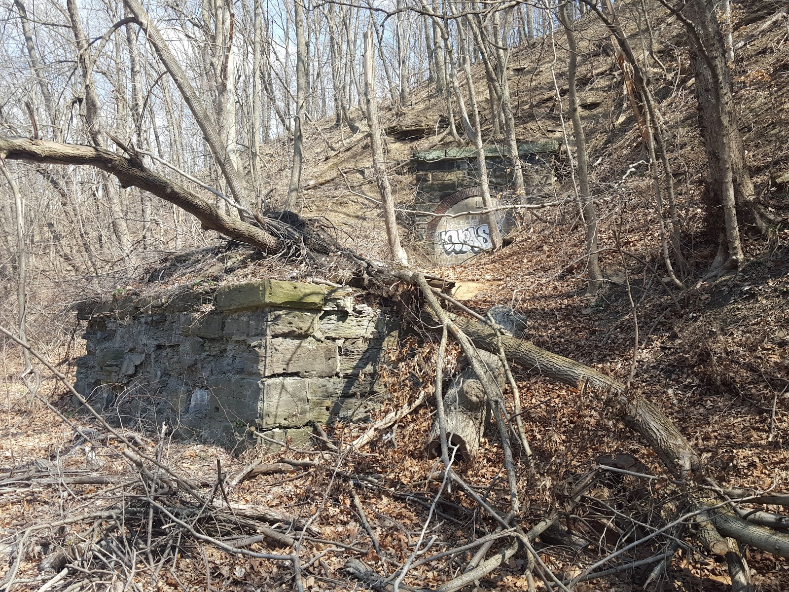
An abutment remains from what would have been a bridge carrying the railroad over Painters Run.


A close up of the stone and brick work.


After this I went looking for the east portal. It was pretty easy to find but not very easy to get to. It sits on the hillside behind a pizza shop along Painters Run Road. Between the tunnel and the pizza shop is Painters Run. I got a photo from behind the pizza shop and that's what I'm using. Maybe someday I'll get over there. Today I was working and not dressed for creek fording.


The east portal.


What's interesting about this is the sign that sits in front of it. The sign reads "Caution Mine Opening".


Zoomed in on the previous photo.


It's obvious that this is the east portal of the railroad tunnel. I started looking into the sign after noticing the west portal looked completely different from the east. The east portal definitely looks like it was redone. Then I found this in the 1886 Geological Survey of Pennsylvania:


"At the west end of the railroad tunnel (which is driven entirely through coal) the Pittsburgh bed is at 865' A. T., and the bed rises through tunnel (half face, half end) to 870' A. T."


What stood out was that the tunnel was "driven entirely through coal". It's very possible this tunnel could have been used as a coal mine entrance after the railroad abandoned it. I have found two other examples of this. One being the Negro Mountain Tunnel, although the tunnel was never completed for use by the railroad there is a coal mine inside of it.  The second is the Radebaugh Tunnel east of Greensburg. The Radebaugh tunnel is completely buried now but after the tunnel was abandoned by the railroad, it too was used for an entrance to the Radebaugh Mine.


Just a theory.

Sunday, March 20, 2016

Lemont No. 1 Coke Works


Lemont No. 1 Mine and Coke Works began operating in 1871 by the Lemont Furnace Company.


This post is under construction....


The 1939 aerial shows two blocks of completely disintegrated ovens.


The 1959 aerial shows one block but it appears to have been rebuilt.


Today there are a few ovens left in the block visible in the 1959 aerial. These ovens are in very poor condition. The portion of the block closest to the road is completely missing. 


This is what's left today.


This is honestly as good as it gets at Lemont No. 2. You can see a very small portion of the stone retaining wall to the left of the oven.

Overgrown and forgotten.


There are ovens on the back of the block still. Nothing stood out as being any different from this side. The other side of the block borders very close to a residence.


These ovens are all just collapsing.


This is all that is left of these ovens.


Sunday, March 13, 2016

Coke Works on the Fairmont, Morgantown & Pittsburgh Branch of the B&O Railroad

Today we took a long walk along the abandoned Fairmont, Morgantown and Pittsburgh Branch of the Baltimore and Ohio Railroad. It was really easy going at first. The problem came with the absence of very necessary bridges. I got as far south as the Atcheson Coke Works and was able to bypass two of the bridges with the Atcheson siding and a little bit of ridge running, but by that point it was getting late, I was getting hungry and I had to repeat the ridge running to get out of there.  The Ada Coke Works are somewhere south of Atcheson and I might try from the other direction. It looks like there could be a few bridges missing from that angle too and Coke Oven Season is almost over for the year. The terrain is pretty rough and the area is extremely isolated. If only the bridges were there.....


Rough outline of the section of railroad branch I followed today (in purple) and the location of the two coke works.


Anyway, I started near Cornish just south of the Outcrop tunnel and started to work my way south. First I stopped at the old Dorothea Coke Works. The Dorothea Coke Works started off as the Sackett Coke Works around 1900. They were built by the H.R. Sackett Coke Company a couple years earlier than the Crystal Coke Works. Sackett operated this plant until 1907 when it was sold to the Iron City Coke Company and the name was changed to Dorothea. 


This very hard to read little article was in the July 6, 1907 Connellsville Courier. It certainly helps with the history though.


It's hard to tell how long the plant operated but in this 1939 aerial it certainly looks active but the construction of the one intact oven indicates it ended pretty early.


At the center of the photograph Dorothea certainly appears to be operating. The tipple is visible but they could have been just using the siding to store railroad cars. With only between 30-40 acres of coal it's hard to imagine it lasting 39 years.


This is the condition of most of the ovens.


A piece of the original block.

Inside.


Towards the middle was this original oven.

It retains its original block.

On the top it looks like somebody slapped together some quick repairs though.

Even between the blocks they wedged bricks in there to hold it together.

It's really clean inside though.


Hardly any cracks and the condition of the brick is incredible.

Right next to it is an almost completely buried oven.

A few more.

The remaining bricks on this oven make it look like it might have operated later.

Strong construction though.

The wood in the foreground could have been part of the retaining wall for the coke yard.


After this it's time to start heading south.


This is the railway after crossing Cornish Road.

This building could have been part of the Cornish Mine which operated here. There were no coke ovens associated with the mine.

This branch shows up on the 1993 county map but it does not appear on the 1996 map.

The amount of railroad ballast that remains certainly makes it look like it operated later than a lot of abandoned railroads I've been on.


Heading south.

A sure sign that Coke Oven Season is wrapping up for the year.

Heading into Crystal Works.

Crossing Main Street at Crystal Works.


Modern looking railroad signs indicated a more recent abandonment.


Pulling into Gans.

I love this building. There was a Burchinal Coke Works near Outcrop.


After this it is just a whole lot of railroad until we get to Atcheson.


A little waterfall off to the side.


Atcheson Coke Works


Atcheson Coke Works was the first coke plant of the Republic Iron and Steel Company of Youngstown, Ohio.   Republic acquired this plant from the Connellsville Coke Company in July of 1899 although there is some mention of the latter company operating it as late as 1902. That year they added 19 new ovens to the 81 they already had. 


Republic Iron and Steel, founded in 1899, became Republic Steel in 1930 and was once the third largest steel corporation in the United States. In 1984 Republic merged with J&L to form LTV Steel which filed for bankruptcy in 2001.


 I can not find any information on when the Connellsville Coke Company first fired the ovens but the coke works would eventually contain a total of 135 ovens. All of the coke produced here was shipped over the B&O to the Republic mills in Youngstown. The plant was probably not operated after 1930 and more than likely shut down around the time of the company's other ovens at Republic, PA


This is a crazy coke plant. There are ovens going in every direction.  They begin (or end) on both sides of a ravine and wrap around the front of each side of the hill. 


This is showing the terrain where Atcheson is located. You can clearly see the railroad grade through the center of the photo. Notice how the ovens wrap around each side of the ravine and the curved siding in front of them. This is a very unusual setup.


Topographic map showing the location.


Road map showing the location. It is very isolated.


These are the first of the ovens you come across.

Everything throughout the site is completely overgrown.


Compare the bricks inside this oven to the bricks inside the Dorothea oven. These ovens were used hard.


The ovens in this more accessible area are in really bad condition.


Completely overgrown.

A small piece of retaining wall.


This is where it starts to get weird. This is the end of this bank. Notice how high those ovens sit.

End cap on this bank.


This is when I noticed the ovens going behind the other bank making an "L" shape.

This is where they start heading back into the ravine.


A piece of floor tile.


This is looking across to the other side of the ravine.

Looking up the center of the ravine. Ovens on both sides.


It looks like it could have been used for a grill at one time.

All this terrain was nasty to get through.

Other side of the ravine.


The further you get up the ravine the closer the ovens come together.

This is above the ovens in the ravine after they ended.


This is looking up the creek to the first of the missing bridges. You can see one abutment on the right.

Quad trail going through the creek up to the railroad grade.

I started walking down the creek and noticed tons of coke along the hillside. You can see the ovens up at the top of the hill.

Looking back at the first missing bridge.

I climbed back up the hill to see if I could take the siding back to the B&O grade.


This fallen tree picked up a piece of track. Probably from a larry car.

An abutment from the second missing bridge.

Up above it was the only intact oven at Atcheson.

Definitely an old hand drawn oven.


The ovens kept continuing.


Some remaining retaining wall.


I finally made it back to the railroad grade. This is looking across at the other abutment.

A number at the top right corner of the other abutment.

This grade is really high above the creek. The the left is a steep hill leading up the siding. It's time to leave.

On the way back I saw another railroad sign. This is a mile marker.

Some rail still existing from the siding that went into the Cornish Mine.