Today, despite the ridiculous cold, was a great day for Mr. Standard to head over into my neck of the woods. We did a good bit of running around and decided to stop and have a look at the entrance to the Mt. Grey Mine. I'm calling this post the four seasons post. Some of these photos may be familiar to you from previous posts but they are all part of the Mt. Grey Mine. The reason I'm calling it the four seasons post is some of these were taken during every season. You'll see green leaves, colored leaves, snow, water, and ice but that's Pennsylvania for ya!
The Mount Grey Mine was the first of the Howard Gas Coal Company Mines. You may remember us exploring Howard's Louise Mines last year near Slickville. The Mount Grey Mine was listed as "just being opened" in the 1904 Report of the Department Of Mines. The only mine map I can locate for this mine is dated 3-12-06.
Later maps of the area show the mine being operated by the Armstrong Westmoreland Coal Company. So like Louise No. 2, this was operated at a later date.

The Howard Gas Coal Company was started by J. Howard Patton. Patton was a superintendent of the Pennsylvania Railroad from 1870 to 1880. After leaving the railroad he moved to Claridge in 1885 and opened a general store. On January 12, 1891 Patton, who was a heavy investor in the newly formed Claridge Gas Coal Company, acquired 170 acres of coal lands south of the Denmark Mine from Greensburg coal magnate George Huff. Three months later he conveyed the land to Claridge Gas Coal Company. Eventually he would become president of the Atlantic Crushed Coal Co., Lucesco Coal Co., Huron Coal Co., as well as Hempfield Foundry and Greensburg Storage and Transfer Co. His son, Howard C. Patton would be superintendent of the Howard Gas Coal Company as well as Huron Coal Company.
 |
J. Howard Patton (Photo courtesy of Mary Jane Shaw) |
The Following article from the May 9, 1918 Connellsville Courier contains some great information on the Howard Gas Coal Company as well as some great information on the expansion of the Turtle Creek Branch of the Pennsylvania Railroad.

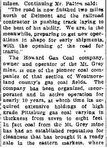


The Mount Grey Mine was a very successful mine. The 1914 output of the mine was 112,750.82 tons of coal. It continued to grow considerably over the next four years when it averaged 150,000 to 160,000 tons a year. Comparing the above article to the following 1914 report from that year's Coal Field Directory, you can see they more than doubled their equipment, going from one locomotive in 1914 to four by 1918. They also traded in two electric machines and six compressed air machines for seven Sullivan shortwall machines.

The most impressive thing about this mine however, was its design. Mount Grey used almost every conceivable technique available to deliver its coal to market. Starting with two drift entries, the coal was hauled across flat land to a steep incline down the side of a mountain. Once it reached the bottom it made a sharp right on a railroad grade across a flood plain along the Kiskiminetas River and made a sharp left crossing the river to the tipple along the Western Pennsylvania Railroad on the Indiana County side.
 |
This is how the mine operated. The piers from the bridge crossing the river still exist as well as some other features located along the river flats. The scale is difficult to comprehend until you look at this map superimposed over an aerial view of the area. |
 Fortunately I prepared the aerial for you.

Now here is the terrain we're looking at.

This setup lasted until 1917 when the bridge collapsed. After this, the coal was trucked through Saltsburg over to the railroad. Sometime after the bridge collapsed a cable car system was installed using the existing bridge piers.
 |
Photo showing the 1917 bridge collapse. Photo courtesy of Ray Washlaski. |
The mine is not listed on the 1923 Pennsylvania Railroad list of stations and sidings and I am not finding anymore information on Mt. Grey after 1920. It's possible the mine was sold and renamed or it was simply worked out and the Howard Gas Coal Company concentrated on its Louise Mines.
 |
The double portal entrance to the Mt. Grey Mine. |


 |
Railroad ties in the flooded left portal. |
 |
The left portal. Fog and nice warm air was coming out of here. |
 |
The right portal. |
 |
Looking out the right portal. |
 |
Looking out the right portal. This is as far in as we walked. |
 |
Brickwork inside the portal. |
 |
Mr. Standard looking like he found a new home. |

Now we're getting into some of the older stuff.
 |
This is part of the mine railroad grade at the bottom. |
 |
Side of the mine grade. |
 |
On top of the grade. |
 |
These are some of the remaining piers at the bottom that would have helped with the incline. It's hard to imagine what this operation looked like. |


 |
This is the toward the bottom of the steep incline. There is still a lot of coal laying around. |
 |
Looking down the steep incline ravine. |


The bridge piers from the land.

 |
Piers from the water. |


Located behind the portals was the company town related to this coal mine. From the maps it appears there were at least 20 houses along with other mine related structures. None of these buildings exist today. Word of mouth states that these buildings were dismantled and moved to the Howard Gas Coal company town of Patton that exists today near Slickville. The former town is referred to as Old Patton.
 |
The mine map showing the existence of Old Patton. |

Although we didn't find any remains of the houses, we did find evidence of another portal that does not appear on the mine maps.
 |
What is very interesting are these street signs on the trees. |
 |
Location of the town site. |
 |
W. Oak Creek. |
 |
These are the piers related to this other portal or air shaft. |


 |
Something was here. |
 |
Another view of the town site. |

After this we walked back over to the main portals. This time armed with flashlights.
 |
Just beyond the brick arched portal. This mine is sealed up. |

 |
A big wheel buried in the dirt inside the portal. |
Note in the name of the mine is Gas Coal. At the turn of the century 1900 many of the Eastern Seaboard cities such as Baltimore and Boston used Street lamps and lamps for lighting that was powered by Gas processed from coal. A large supplier of this coal was from Westmoreland County Pa thus you see in the name of many coal companies Gas Coal. Irwin Gas coal and Penn Gas Coal just to name a few. Enjoy reading these Old Industry articles. Future generations of Historians will have a Gold mine of information.
ReplyDeleteHave seen those piers when canoeing from Saltsburh to Roaring Run. Glad to know the story.
ReplyDeleteWhere is this near
ReplyDeleteWonderful site. Thanks for sharing. According to the links below Howard become an agent for the PRR in Claridge but didn't resign from the PRR until 1906.
ReplyDeletehttps://books.google.com/books?id=45A5AQAAMAAJ&lpg=PA109&ots=n-doIQodsU&dq=j%20howard%20patton%20howard%20gas&pg=PP7#v=onepage&q=j%20howard%20patton%20howard%20gas&f=false
https://books.google.com/books?id=xzkwAAAAYAAJ&pg=PA212&lpg=PA212&dq=%22j+howard+patton%22&source=bl&ots=io9tRoIt4A&sig=eb0JejxtEAQ3iWtUUS-I7eSQY5g&hl=en&sa=X&ved=0ahUKEwjxmsLptfjYAhWEmOAKHXinCuQ4ChDoAQgrMAE#v=onepage&q=%22j%20howard%20patton%22&f=false
Thank you very much! That second one is incredible. I saw the first one, I have never seen that second one. Thanks!
DeleteMy family and I lived down river in Avonmore from 1900 to 1970. Some of the homes were removed by the coal companies but all of the remaining structures were wiped out in the 2nd Johnston Flood, March 9,1936 A restaurant in Saltsburg has the high water mark still painted on the wall. One mile down river across from Avonmore was also the coal mining town of Edri. It and its train station was also swept away. The railroad bed at the bottom of the incline extended on the Westmoreland Co side of the river to the town of Salina. The Helena train station was located at the crossroad across the intersection from the Dollar store Keep up the good work. Great article and photos.
ReplyDeletehttps://www.west2k.com/papix/edri.jpg
ReplyDeletephoto of Edri Train Station
Any information on the former bridge across the kiski river and the 3 piers on the Saltsburg side of the river? Some sort of unloading process there to haul out on the main line?
ReplyDelete