Yesterday Lou and me got finally got a chance to head out into the woods. It was still pretty soggy in spots, but overall it wasn't too bad. The main point of this trip was to identify and locate two wye's that appeared at two different times and places along the railroad. Another goal was to locate the site of the old railroad station and the foundations of other buildings.
 |
This 1939 aerial shows the original wye, as well as the railroad station. |
First, this section was opened from Crabtree to New Alexandria in November 1900. We located the original wye thanks to the farmer giving us full access to the property. This area is so unbelievably overgrown that it was difficult to photograph. As you can see on the 1939 aerial, there were quite a few buildings in the area of the New Alexandria Station. Due to how overgrown it is, it is extremely difficult to navigate this area. We did locate some foundations but nothing to positively identify anything by. A few years ago, the Stuff That's Gone boys did locate what was believed to be the location of the station. This was my second time back there and I still couldn't find it. To make matters worse, it's all flat up there, so there are no recognizable fills or cuts to follow on the old railroad ROW. A compass is in order if I were to make this trip again.
 |
Postcard of the New Alexandria Station. |
 |
Another view of the station. Photo from the book "200 Years of History 1776-1976" 1976, The Bicentennial History Committee, New Alexandria. |
 |
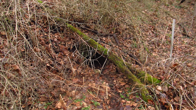
Photo of the possible ruins of the station from Stuff That's Gone. |
The second wye is further west and appears on the 1957 aerial.
 |
As you can see on the 1957 aerial, the whole upper wye has been eliminated. The railroad was realigned, even Galando Road was rerouted to accommodate the new railroad alignment. The farm was decimated, probably for a second time. At this point in time, the railroad heading up to Andrico was no longer used and abandoned. The terminus of this branch would have been the Salem Mine and Coke Works in Salemville. |
 |
1964 topographic showing the new alignment, as well as the coke ovens at the Salem Mine. The coke ovens are no longer there. |
Heading out! We initially heading south towards Crabtree to locate the section where the old alignment met the new alignment. We followed the grade as far as we could until we came across a farm and had to turn back. I followed the grade from Crabtree to the other side of the farm a couple years ago. You can see that in this post.

Looking at the newer grade from Galando Road.

The cut coming out at the curve on Galando Road.

Looking west after crossing Galando Road. The grade is to the left of the fence posts and right of the tree line.

Crossing at Galando Road.

Where the original grade crossed Galando Road.

Heading toward Crabtree on the original grade.
Drainage pipe under the new grade.

Old grade toward Crabtree.

This is where the grades changed. The newer grade is to the left, the old grade is lower and on the right.

Separation. The tree toward the middle of the photo separates the grades.

Heading toward Crabtree.


Looking at the newer grade from Galando Road.

The cut coming out at the curve on Galando Road.

Looking west after crossing Galando Road. The grade is to the left of the fence posts and right of the tree line.

Crossing at Galando Road.

Where the original grade crossed Galando Road.

Heading toward Crabtree on the original grade.

Drainage pipe under the new grade.

Old grade toward Crabtree.

This is where the grades changed. The newer grade is to the left, the old grade is lower and on the right.

Separation. The tree toward the middle of the photo separates the grades.

Heading toward Crabtree.


After this we headed up to the road and walked back to the farm. It was easier than fighting the jaggers again. We then followed the new grade west toward Frogtown.

We found some old foundations off the grade in the woods. Probably farm related.


Old spring.

This was nice walking!


This is where the original alignment came in. On the left. This would have been the west leg of the old wye. Straight is the new alignment heading toward the farm.

Washed out sections of pipe under the grade.

Unwashed out section of pipe on the other side.

Crossing on Archway Drive in Frogtown.

Grade looking west toward 119.


At the 119 crossing.

This is the western "top" of the wye.

Salem coke laying around.

License plate I found.

Grade at the top of the wye. This runs along 119.

Lou checking out the wye.
After this we headed back to the farm and took the original alignment, western leg of the old wye, up towards the arch and New Alexandria.

The left heads to New Alexandria, the right is the lower portion of the old wye.

The grade to New Alexandria.

One of the old foundations.


Grade to New Alexandria.

Old pillars. We couldn't find any mines ever being back here. We initially thought they were from the platform to the old station, but the topography doesn't fit. Coal station came up as well, but we can't find anything that suggests that there was one back here. All we have are old pillars.


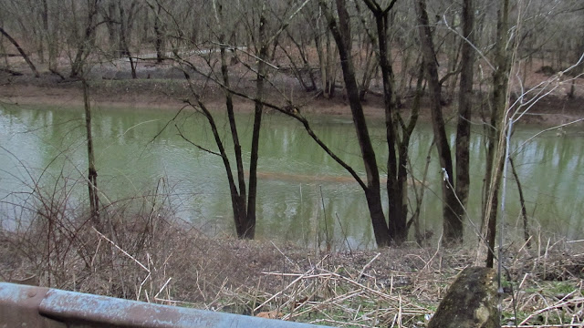
Finally made it to the arch. Loyalhanna was very low for some reason. The piers from the old New Alexandria William Penn Highway bridge are visible in the water.


The arch still stands. There isn't a person alive that can remember when this arch wasn't here.


The left heads to New Alexandria, the right is the lower portion of the old wye.

The grade to New Alexandria.

One of the old foundations.


Grade to New Alexandria.

Old pillars. We couldn't find any mines ever being back here. We initially thought they were from the platform to the old station, but the topography doesn't fit. Coal station came up as well, but we can't find anything that suggests that there was one back here. All we have are old pillars.


Finally made it to the arch. Loyalhanna was very low for some reason. The piers from the old New Alexandria William Penn Highway bridge are visible in the water.


The arch still stands. There isn't a person alive that can remember when this arch wasn't here.

After this, we once again walked the road back to the farm and got out of there. We stopped in Salemville really quick to look at this old hopper, left over from the Salem Mine.


Mike....nice pics and info....did you look underneath the hopper? Me and a buddy were there a year or two ago and saw what looked like a tunnel going as far back as the eye could see...pretty collapsed though. Lots of reddish orange water too, you'd need chest waders to get back there....maybe an entry? Thx.
ReplyDelete