Today was a great day to get out and do some pre-coke oven season exploring. Summer is gone and I thoroughly enjoyed every moment of it. I spent a lot of time researching plenty of coke sites, so this is definitely going to be a very busy year. There's a lot left out there. Today I focused on some of these iron furnaces I was looking into and went to check them out. It was a great afternoon to spend in the mountains. The first three of these furnaces are located around New Florence and the last (and my personal favorite) is south of Laughlintown. Dates of construction range from 1810 to 1850 presumably, information on these sites is sketchy at best and it seems like nobody agrees on anything. The majority of the information I am using is from the 1966 book "A Guide To The Old Stone Blast Furnaces In Western Pennsylvania" by Myron B. Sharp and William H. Thomas. The two sites that have been restored have signs describing the history of the furnaces. For these sites I am using the information from the signs. I figure if they took the time and resources to restore these massive furnaces, they probably did a substantial amount of research on their history.
Baldwin Furnace
The Baldwin Furnace is located in State Games Lands #42 in St. Clair Township. This is the earliest of the four. According to the book, Baldwin Furnace was constructed in 1810 by James Stewart and Henry Baldwin and was only in blast for a short time. It was a charcoal fueled furnace and I found slag laying around that still had charcoal and iron in it. That's it for information on this furnace.
 |
A short walk up this road leads you to the furnace site. |
 |
Approaching Baldwin Furnace. |
 |
As you can see, the back side of it is in pretty bad shape. |
 |
Climbing down the hill to the furnace behind this retaining wall. I am assuming it's been rebuilt. The game commission keeps this area cleared of brush which is one of the main reasons this furnace is still standing. |
 |
The side of the furnace. |
 |
Looking inside the side arch. |
 |
The front and side arches. |
 |
The stonework is amazing. |
 |
The intricate detail of the stonework done 206 years ago. |

 |
Engravings in a tree from previous visitors. |
 |
Again. The stonework. I wasn't able to locate any mason marks in the stone and it's almost certain the names of the craftsmen are lost to time. |
 |
The other side of the furnace. This side also contains remnants of what could have been the race to turn the water wheel and operate the bellows to blast the furnace. |
 |
Possible race. |
 |
It heads down toward Baldwin Run. |
 |
Baldwin Run. |
 |
More cut stone near what may have been the race. |
 |
Some of the furnace slag. |
 |
A final look at Baldwin Furnace. |
Laurel Hill Furnace
Laurel Hill Furnace is located close to Baldwin Furnace but it's off state game lands. It is located conveniently on Furnace Lane outside of New Florence. This is one of the furnaces that has been preserved and is currently under the supervision of the National Park Service. According to the book, this furnace was built during 1845-46 by Hezekiah Reed, Gallagher and Hale. It was later owned by Judge J.T. Hall of Centre County. This furnace operated until 1855.
 |
Laurel Hill Furnace. |
 |
The informational sign at the site. The information on this sign is identical to that in the book. |
 |
What I love about these furnaces is that they're all unique. They all served the same function but none of them look the same. Some have these massive arches and others have openings that come to points. The arches are 12 feet high. Another unique feature of this furnace is that all four sides have arches. |
 |
A look inside the front arch. Three iron bars support the structure. |
 |
Looking up the stack. |
 |
Slag coated on the brickwork of the stack. |
 |
I'm guessing this is the hole where the molten iron flowed from. |
 |
Inside the furnace. |

 |
This masonry work is still incredible but it's not as tight as Baldwin Furnace. |
 |
The arches on the other hand..... |
 |
The whole furnace is fastened together with these tie rods. |
 |
From inside the furnace. Probably where the molten iron flowed out. |

 |
A final look at Laurel Hill Furnace. |
Ross Furnace
This was the trickiest one to get to. It is located on a golf course in the Ross Mountain Club, a country club. I am not a country club kinda guy (picture Bill Murray in Caddyshack). The area is heavily posted with Members Only signs so I did the only thing a fella in my situation could do. I snuck in. It was successful, I got my photos and got out. According to the book, Ross Furnace was constructed in 1815 by James Paull, J.D. Mathiot and Isaac Meason. This furnace was in blast until at least 1850. Aside from making the usual pig iron, Ross Furnace also produced pig iron stoves, sugar kettles, pots, ovens, skillets etc.
Meason is a huge name in local industrial history. He was the first man to make a fortune west of the Alleghenies in the iron business. Most of his interests were in Dunbar, Fayette County including his Union Furnace on Dunbar Creek which was producing iron by 1791. By 1788 he owned thousands of acres of land and was the wealthiest man in Fayette County.
 |
It's a shame it's hidden on a golf course but they seem to be taking great care of it. |
 |
The inside of these arches is different from the others. |

 |
Looking up the stack. It's all cleaned up. It looks like it's coated with concrete. |
 |
More heavy iron supports. |
 |
This furnace has both arches and points. This is the back side facing the golf course. |
 |
Tight corners. |

 |
Incredible stonework. |
 |
Detail of the arch. |

 |
Final look at Ross Furnace. |
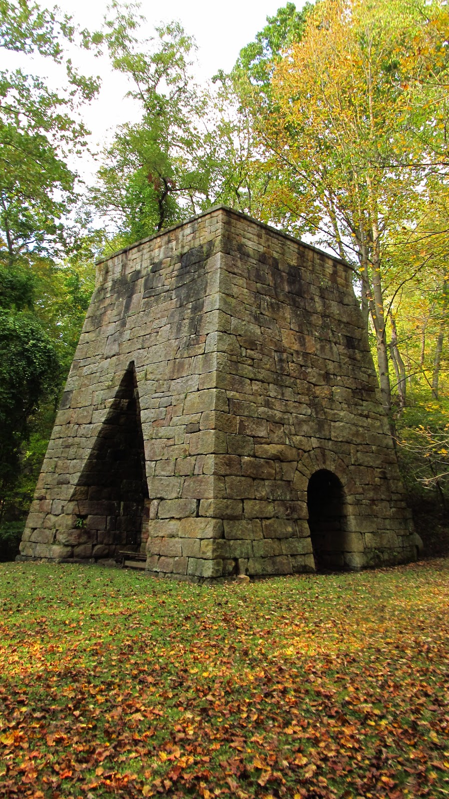
California Furnace
This was my favorite location from today. The book says the furnace was constructed in 1853, the sign says 1850 and the 1994 inventory of historic engineering and industrial sites says 1852. What they all agree on is the furnace was built by Col. J.D. Mathiot and Dr. S.P. Cummings. This is the second time Mathiot has popped up but the first time he's listed as a Colonel. The furnace is located on the old Philadelphia and Pittsburgh Turnpike along Furnace Run. Furnace Run was known as California Run at the time. California Furnace was later sold to Alexander Cavat, who supposedly invested a fortune into it but didn't see a profitable return. The furnace went out of blast 1862. In 1966 Gen. Richard K. and Constance Prosser Mellon restored the furnace.
 |
To get to California Furnace you get to cross this covered bridge. |
 |
It is called the Naugle Bridge. I haven't been able to find a construction date. |
 |
If you're too heavy, you have to go through the creek. |
 |
Furnace Run, Google Maps calls it Rolling Rock Creek. |
 |
The sign that is at the furnace. |
 |
Diagram showing the operation of iron furnaces. |
 |
California Furnace. |
 |
Incredible. |


 |
This ring is leaning against the back of the furnace. |


 |
This is on the left side of the furnace in an arch. Adjacent to this is the race where the water wheel went so this would probably be where the bellows blasted the furnace. |
 |
Looking toward the race. |
 |
Looking up from where the water wheel sat. |
 |
Looking through the race. |
 |
Down where the water wheel sat. Another one of those rings is also done here. |
 |
This is under a small plank bridge on the left side of the furnace. |
 |
Looking up at the arch. |
 |
The plank bridge from the top. |
 |
The front and the left side where all the other stuff is. |
 |
Inside the front arch. |
 |
Looking up the point. |
 |
Foot bridge over the creek. |
 |
Heading back out over Naugle Bridge. |
Jacob Davies Mathiot
I was able to locate the following information on Col. J.D. Mathiot.